- Satteläcker 17, 70565 Stuttgart, Germany

Relative positioning is different from absolute positioning. An independent receiver must perform positioning based on navigation message information. In relative positioning, the unknown point’s location is determined relative to a known point (based on the BASE LINE definition). Some people confuse relative positioning with differential positioning, although differential positioning uses only code measurements and can achieve accuracy around 0.5 to 1 meter. DGPS (Differential GPS) equations use ground-based reference stations that track satellites. The correction information calculated by these reference stations is sent via communication systems to compatible receivers, which then use this data to correct their coordinates. Relative positioning uses both phase and code measurements. An example of this method is Real-Time Kinematic (RTK) positioning, which is used in dual-frequency receivers. RTK surveying is one of the most interesting innovations in relative positioning, where two receivers are linked via radio or the internet to simultaneously collect phase observations. This method is applicable in various high-precision positioning tasks, such as cadastral surveys, engineering surveys, navigation, and mobile mapping. Relative positioning methods include RTK, static, PPK (Post-Processed Kinematic), and Stop and Go, each briefly described below:
The Real-Time Kinematic (RTK) method is used for differential positioning through carrier phase measurements. RTK allows achieving centimeter-level accuracy in real-time. In this method, a base receiver is set up at a point with known coordinates, and data is transmitted in real-time to a mobile receiver. The mobile receiver processes this data to improve positioning accuracy. The positioning error in RTK increases with the distance between the reference receiver and the mobile receiver. RTK is available in two forms: classic RTK and RTK over the internet.

In the static positioning method, at least one of the points has known coordinates. One receiver is placed at the known point, and the other receiver is positioned at the unknown point. Both receivers must simultaneously collect observations. The method is based on forming a baseline and solving the baseline vector. This approach can achieve millimeter-level accuracy. It is used for establishing permanent points or benchmarks. Accuracy improves with longer observation periods or shorter baselines.
The Stop & Go method is a kinematic approach. It involves initial setup and observation at specific points where precise coordinates are needed. Observations are taken for several minutes at each point while maintaining communication with satellites. The procedure starts by performing observations at one unknown point for a few minutes, then moving to another point and repeating the observations there. This process is carried out for all unknown points. After one to two hours, you return to the first unknown point for additional observations, and the same procedure is followed for other unknown points.
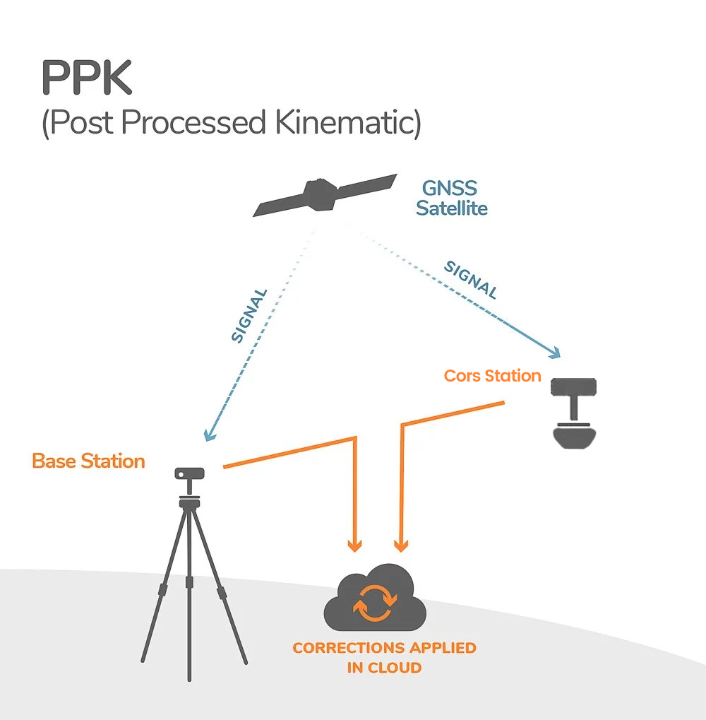
The PPK method is similar to RTK but differs in that corrections are applied post-processing rather than in real-time. In PPK, unlike RTK, corrections are made after data collection using separate software, and the quality of results depends on data collection methods, environmental conditions at the time of collection, and the processing software’s capabilities. Both RTK and PPK methods have their specific advantages:
PPK Advantages: Particularly useful in areas with inadequate communication facilities for real-time corrections. In such cases, raw data can be stored similarly to static methods and post-processed later. During data collection for PPK, you can set up at specific points and gather more data similar to the Stop & Go method. Additionally, PPK allows for observing the receiver’s position in each epoch during movement after processing.
Both static and PPK methods require specialized software for processing. For PPK post-processing, the ShimiM online system can be used, or office software such as LGO can be utilized for data processing.

References:


Nerxon is set to present its latest advancements in GNSS technology at the upcoming INTERGEO 2024 exhibition in Stuttgart, taking place from September 24 to 26, 2024. This prestigious ...

Advanced Mobile Application and Seamless Integration Nerxon’s mobile application, developed to give users complete control over the device, comes equipped with integrated Augmented Reality (AR) features. This offers an ...

Nerxon Unveils Revolutionary GNSS Technology at INTERGEO 2024 Nerxon is excited to announce the launch of its latest breakthrough in GNSS technology at INTERGEO 2024, a leading global event ...

Nerxon Unveils the N900: A Revolutionary Visual Positioning System with Integrated GNSS Technology Nerxon is proud to announce the release of its latest innovation, the N900—a cutting-edge Visual Positioning ...

+491635197153
Satteläcker 17, 70565 Stuttgart, Germany
info@nerxon.com